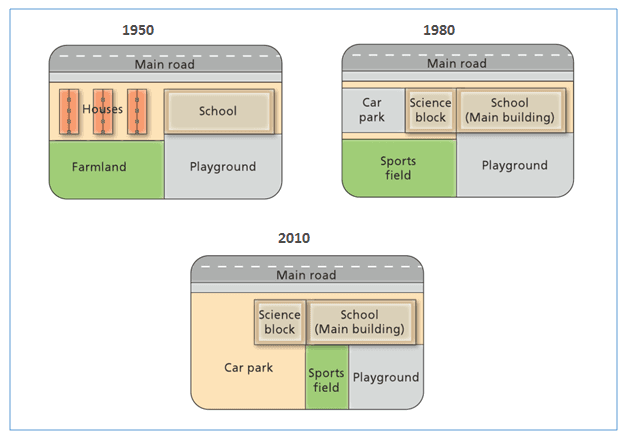
The diagrams below show the changes that have taken place at West park Secondary School since its construction in 1950.

The maps illustrate how West
Park
Secondary School
transformed after some developments in three main years from 1950 to 2010.
Overall
, it is clearly seen that the secondary school
witnessed a remarkable renovation by replacing some new area
throughout the shown period.
Fix the agreement mistake
areas
According to
the 1950 map, West Park
Secondary School
had only one building with its playground surrounded by houses and a
farmland. Remove the article
apply
However
, after a period of 30 years, the residential area was made into parts of the school
. A science block was constructed adjoining the main building, and on the left-hand side of it was a car park
.
The redevelopment of the school
between 1980 and 2010 demonstrates a significant change. Sports
field was the new area which replaced the previous farmland in 1980. Add an article
The sports
Nevertheless
, its sized
was minimized and relocated Replace the word
size
next
to the playground - which was also
made smaller in order for the car park
could be extended.Unauthorized use and/or duplication of this material without express and written permission from this site’s author and/or owner is strictly prohibited. Excerpts and links may be used, provided that full and clear credit is given to Writing9 with appropriate and specific direction to the original content.
Vocabulary: Replace the words park, school with synonyms.
▼
Vocabulary: Only 4 basic words for charts were used.
▼
Vocabulary: The word "maps" was used 2 times.
▼
Vocabulary: Use several vocabularies to present the data in the second paragraph.
▼