
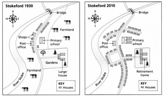
The assigned maps illustrate the alternation that took place in the countryside area of Skoeford in two periods 1930
as well as
2010.
At a fleeting glance,it is crystal clear that in the initial year, there was farmland Linking Words
along with
the river stroke and beside the gardens which had been knocked down after 8 decades.Linking Words
Likewise
,the gardens on the southeastern side were demolished too.Surprisingly,the post office,primary school and bridge remained the same throughout the period.
Probing ahead,the pin-pointing change is the number of housing that increased drastically by 2010.The place of farming Linking Words
together with
shops was occupied by houses in the latter year.Linking Words
Similarly
,the large houses had converted into retirement homes.Linking Words
Lastly
, the areas of primary school were enlarged by 2010.The path connecting the river stroke road to the large houses was Linking Words
also
eradicated.
Linking Words
Overall
, a major change was witnessed in housing,which escalated in the latter year.Linking Words
In contrast
, the farmland, shops and gardens were totally removed.Linking Words