
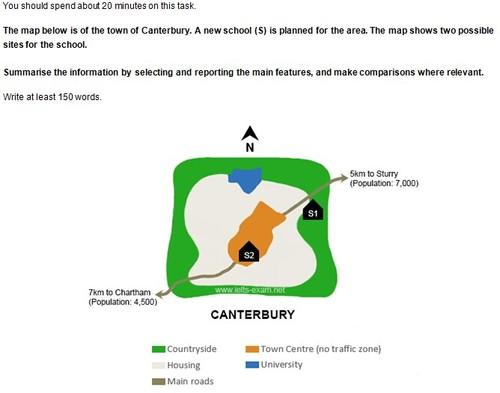
The map of Canterbury displays the
town
's layout, including two potential Use synonyms
school
sites.
Use synonyms
Overall
, Linking Words
it is clear that
the countryside encircles the residential area of the Linking Words
town
, and the Use synonyms
Town
Use synonyms
Centre
is located in the very middle of the city. In the northern reach is located the university, and the two main roads connect the southwest corner to the northeast corner of the Use synonyms
town
.
Looking at the map closely, the first candidate site for the Use synonyms
school
is located in the east countryside, looking out over the main road heading to Sturry, another Use synonyms
town
with a population of 7,000 people. The map shows it takes 5km to reach Sturry from the Use synonyms
Town
Use synonyms
Centre
.
Another possible site for the Use synonyms
school
is located in the Use synonyms
Town
Use synonyms
Centre
, where no vehicles are allowed. Within the Use synonyms
Town
Use synonyms
Centre
, the Use synonyms
school
would be constructed in the slightly southern region, and the other main road to Charthna leads off from the Use synonyms
school
. It takes 7km to reach Chartham from Use synonyms
this
possible Linking Words
school
site.Use synonyms