
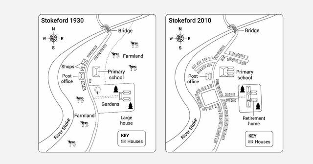
The maps illustrate how a village called Stokeford has developed in 1930 and in 2010.
Overall
, what stands out from the pictures is that there has been significant development in terms of residential areas.
Regarding the maps,there was one main Linking Words
road
in 1930 and it has been added three branches.A number of houses have occupied the space Use synonyms
as well as
Retirement homes along these branches where shops and gardens used to be.Linking Words
Besides
, there was the river which ran from the southwest of the village to the northeast of the area. It has intersected with the main Linking Words
road
at the top of the site and above them,the bridge was constructed which has not changed in 80 years.
Another striking change is that there was farmland along the river and to the east of the main Use synonyms
road
as well and they have been demolished.Use synonyms
Furthermore
,the primary school was situated on the east of the Linking Words
road
which was not developed until 2010 and to next it,many houses have been erected.Use synonyms