
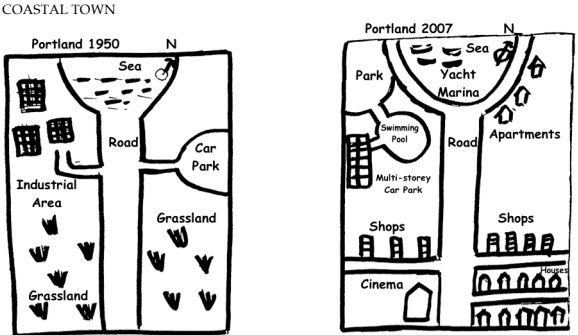
The diagrams compare the changes in a coastal town between 1950 and 2007.
From the
overall
perspective, more public buildings and residences had been built by 2007, Linking Words
while
the main Linking Words
road
nearly remained unchanged.
Use synonyms
According to
the first map, most of the land of the provided town was Linking Words
grassland
, which was divided into two parts by the central roads that led right to the seaside. Three buildings were distributed in the industrial area, which is located northwest of the map. A car Use synonyms
park
was located on the northeast corner of the map. The car Use synonyms
park
and the industrial area were linked by a small Use synonyms
road
crossing to the main roads.
In the second image, the majority of Use synonyms
grassland
had been developed. The western Use synonyms
grassland
had been replaced by public buildings or facilities, which were a Use synonyms
park
, a swimming pool, a multi-stories car Use synonyms
park
, and a cinema from north to south, respectively. Use synonyms
On the contrary
, Linking Words
grassland
was used for residences, Use synonyms
such
as apartments and houses. The small secondary Linking Words
road
had relocated to the southern part of the town, with some shops operating along the north side of Use synonyms
this
Linking Words
road
. Use synonyms
Besides
, a yacht marina was built along the seaside.Linking Words