
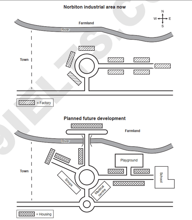
The maps depict a current industrial area to the east of Norbiton and redevelopment plans.
Overall
, the goal is to redevelop into a residential neighbourhood, with additional housing and other supporting facilities.
Currently, there is a traffic circle that connects a southern and an eastern roadway, with several factories in the area that are to be demolished for the purpose of redevelopment.
The futuristic plans upgrade the eastern roadway with enhanced connectivity to modern facilities i.e. housing, school and playground. Linking Words
Moreover
, another lane is planned to be added from the north of the roundabout which connects the cross-river, with housing following the western side of the street. The farmland in the north of the river is to be replaced by additional housing where a way parallel to the river is to be constructed and linked to the roundabout . Linking Words
Additionally
, connectivity is to be planned northwest direction from the roundabout. More housing is to be built along one side and where the road ends.
The development authority made amenities like shops and medical centres easy to access through the roundabout, both facilities are on either side of the streets. In comparison with the present plan, a second roundabout is Linking Words
also
to be added where the south road currently meets the main road at a T-section.Linking Words