
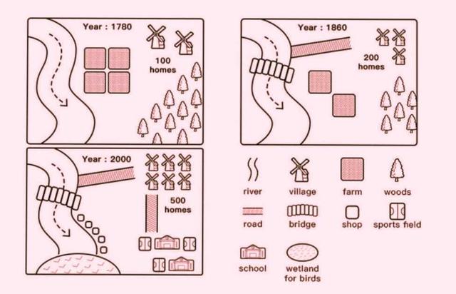
the maps given illustrate the renovations which happened to the town in the time period between 1780 to 1860 and 2000.
Overall
, it can be seen that there has been no change in the position of the river and as time went by, the town was modernised gradually and more people started constructing accommodation there. a lot of changes were made between the years 1860 and 2000.
Linking Words
Firstly
, in the area where the four farms used to be in 1780, two of them shut down and a bridge was constructed to cross the river in 1860. there was an addition of a village and there was Linking Words
also
a road built from the upward riverside to the village area for travelling. in 1780 there were 100 residences Linking Words
whereas
, in 1860, 100 more residences were constructed. Linking Words
in contrast
, almost half of the Forest was cut down for Linking Words
further
development.
in the end, from 1860 to 2000 three more villages were added and 300 houses were built,making it 500 homes. the area of vegetation was completely demolished and was replaced by 2 schools and three sports fields. for the transport of the citizens, a road was built connecting villages and homes to the schools and sports fields. five shops were Linking Words
also
added on the bottom riverside followed by a wetland for birds Linking Words
at the end
of the riverLinking Words