
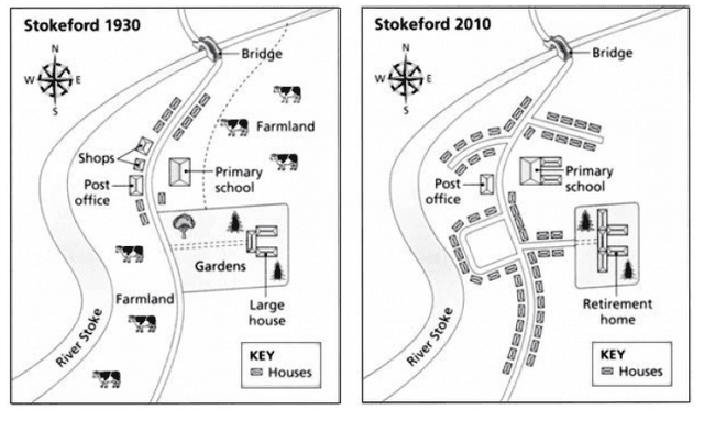
The images display the two maps of the changes that occurred in the village of Stokeford between 1930 and 2010.
Overall
, it is apparent that many variations had occurred Linking Words
such
as the construction of new homes , the disappearance of farmland and the reduction of gardens in Stokeford, Linking Words
whereas
some remain things remain unchanged in the given time period.
Linking Words
To begin
with, in the north-west side , in 1930, there were some shops and homes established, Linking Words
while
in 2010, the shops were completely replaced with the construction of new residential buildings and the post office present there experienced no change Linking Words
Furthermore
, the farmland on both sides of the road was completely disappeared in 2010.
Moving towards the remaining information,in the former map , there were big gardens in the southeast direction, whilst they were fully destroyed in the latter map.Linking Words
Additionally
, the large houses in the same direction were converted into retirement houses in 2010.Linking Words
Finally
, the primary school on the northeast side in 1930, was expanded with two more buildings in 2010.Linking Words