
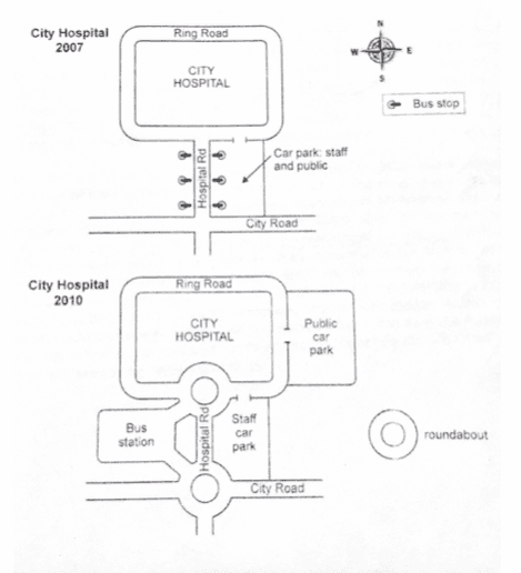
Both maps illustrate how switched access to the roadway in a city healthcare centre was between 2007 and 2010.
Overall
, the town hospital had lots of changes over the three years. Especially parking area and coach station were separated. The urban hospital was enlarged east way Linking Words
due to
the public park.
In 2007, the city hospital had a main 3 street named a ring lane around it, the other hospital road can go directly inside, and the Linking Words
last
urban road intersects with the hospital road. Linking Words
However
, three years later, those ways had two roundabouts. Linking Words
On the other hand
, the parking area and the autobus terminal are separated from each other. In the beginning, the healthcare centre had a bus location on the two ways just a minimal space was a parking field that belong to staff and the public. After a few years, the government transformed the parking area. They divided all parking lines. On the west of hospital street was the bus site, and on the opposite side staff car park. Linking Words
In addition
, people added one exit way and that place happened public car park.Linking Words