
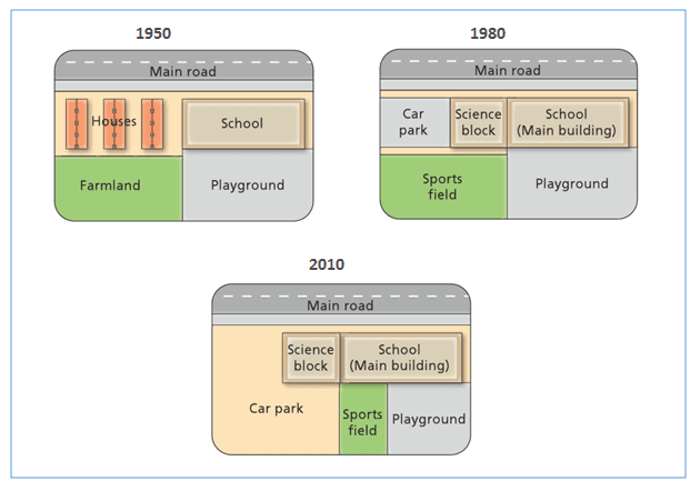
The diagram illustrates the transformation of West Park Secondary School from 1950 to 2010.
Overall
, houses and farmland which existed in the west have been replaced by other facilities for parking, science learning and sport.
Linking Words
According to
the maps of 1950 and 1980, a major construction occurred in half of the Linking Words
place
in the west. Use synonyms
To begin
with, in 1950, the school occupied only half of the Linking Words
place
in the East with the school in the North and the playground in the South. Use synonyms
However
, the farmland and houses located in the East were destroyed to build a car parking area and a science block in the North and a sports Linking Words
field
in the South. Use synonyms
In addition
, there were no significant changes taking Linking Words
place
in the Eastern half.
With respect to the pictures of 1950 and 1980, there was an extension of the parking area Use synonyms
while
the size of the sports Linking Words
field
shrank. The parking for vehicles increased dramatically as they occupied the entire Use synonyms
place
of the sports Use synonyms
field
. Use synonyms
Furthermore
, a new Linking Words
field
for exercise was constructed in Use synonyms
place
of the playground in the East.Use synonyms