
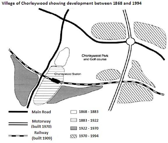
The
map
above illustrates the Use synonyms
development
of the village called “Chorleywood”, located near London from 1868 to 1994. The legends below the Use synonyms
map
infer the Use synonyms
development
of different yearsUse synonyms
,
and the type of Remove the comma
apply
roads
constructed.
Use synonyms
First,
Chorleywood has developed based on their construction of the transportation routes. Linking Words
According to
the Linking Words
map
above, the motorway, built in 1970, intersects the main Use synonyms
roads
below the Chorelywood Park and golf course. Use synonyms
Moreover
, another railway was built at the right side of the park in 1909, which intersects both main Linking Words
roads
and Use synonyms
motorway
.
Fix the agreement mistake
motorways
Next,
based on the Linking Words
map
, the legends show the Use synonyms
development
of the village which Use synonyms
is surrounding
the Wrong verb form
surrounds
roads
and railways. From 1868 to 1883, a small area between the left main road and the park was developed, and from 1883 to 1922, a larger area was Use synonyms
then
developed below the previous Linking Words
development
. Use synonyms
However
, during that time, Linking Words
while
the railway was built in 1909, Chorleywood Station Linking Words
also
appeared. Linking Words
In addition
, from 1922 to 1970, different areas were developed below the railway, forming a V-shape. Linking Words
Finally
, a significant amount of Linking Words
lands
had made Fix the agreement mistake
land
their
progress at the upper side of the main road and Correct pronoun usage
apply
North
and East Correct article usage
the North
side
of the motorway.Fix the agreement mistake
sides