
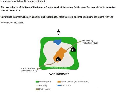
The given map illustrates the expansion of Canterbury, where a novel institution is going to be constructed with two diverse suggestive schemes for its location.
Overall
, Linking Words
it is clear that
both sites are parallel to the main road, but S1 would be presented in the green area Linking Words
while
the other one could be implemented in the city centre.
Linking Words
To begin
with the details, S1 is about to be built in the countryside, apart from the middle, with the advantage of being close to the nearest land in the name of Sturry, which has a population of seven thousand. Linking Words
Furthermore
, the university would be on the northwest side of it, at which point the street would not have access to the institution.
Linking Words
Moreover
, as for S2, it would be the best place since it is going to be near shelters, the avenue, and Linking Words
additionally
, the centre, at which point it is closed to traffic completely. Unfortunately, it will be settled seven kilometres away from Chartam, with approximately four million city residents.Linking Words