
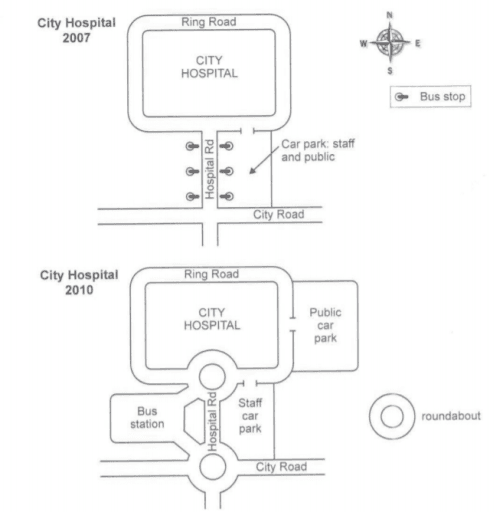
The maps demonstrate transformations to the transport infrastructure that occurred around a city hospital from 2007 to 2010.
Overall
, there were dramatic extensions of the parking and a bus station and roundabouts were Linking Words
also
added to facilitate access to the hospital.
Starting with the picture of 2007, the city hospital was surrounded by Ring Linking Words
Road
which only connected to Hospital Use synonyms
Road
in its south. There was Use synonyms
also
City Linking Words
Road
that was in the far South perpendicular to Hospital Use synonyms
Road
. Only one parking area existed for the staff and the public on the eastern side of Hospital Use synonyms
Road
and six bus stops were located on both sides of the Use synonyms
road
.
Turning to the map of 2010, dynamic changes took place to increase more spaces for transportation. Use synonyms
For instance
, the old parking area became exclusive to the staff and another place for vehicles was built to the east of the hospital off Ring Linking Words
Road
for public use. Use synonyms
In addition
, a bus station was newly constructed across from the staff's parking area, to which two roundabouts built at both the north and south ends of Hospital Linking Words
Road
connected.Use synonyms