
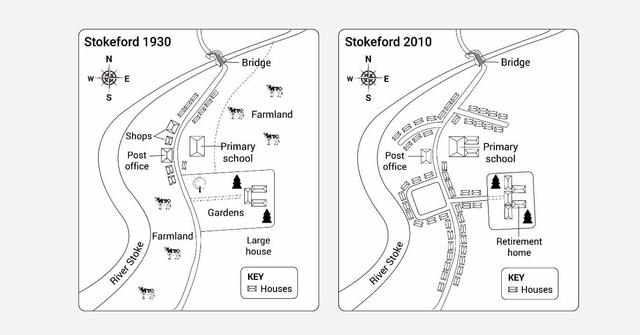
The map given illustrates the development of the village of Stokeford over a period between 1930 and 2010. From an
overall
perspective, it is evident that the town has transformed from a rural area with a lot of farmland to an urban zone with numerous Linking Words
accommodation
.
As can be seen on the map, farmlands located in the northeast as in the south of the town had been eliminated to make way for new houses. In the centre of the village, a post office and a primary school had remained the same, Fix the agreement mistake
accommodations
however
, the school had been extended. Shops had been destroyed to make space for the construction of housing, Linking Words
thus
, two new roads have been built to connect them.
In the east of the village, gardens and a large house had been turned into a retirement home. From the west of Linking Words
this
facility, a new neighbourhood had been established. Linking Words
Moreover
, a host of townhouses had been placed along the road that runs from the north to the south with a bridge to cross a river stoke.Linking Words