
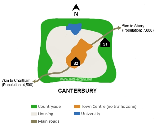
The map illustrates the planning of a new school's location in the
town
of Canterbury. There are two possible sites for the school.
Use synonyms
Overall
, the two considering locations are S1 and S2, both of which are in the Linking Words
town
of Canterbury. S1 is in the Use synonyms
town
centre, Use synonyms
while
S2 is in the urban Linking Words
area
. Use synonyms
Moreover
, there is a university in the north of the Linking Words
town
and a southwest- northeast band of main road leads to the other two towns.
Use synonyms
According to
the map, there are several informations about S1. Linking Words
First,
S1 is located in the north east of the Linking Words
town
, which is Use synonyms
also
in the countryside of the Linking Words
town
. Use synonyms
Second,
the housing Linking Words
area
is on the west Use synonyms
side
of S1. Between the residential Use synonyms
area
and S1 is the main road that leads to Sturry, which is a small city with 7000 residents. Use synonyms
Furthermore
, the university, which is in the north of the Linking Words
town
, is on the north-west Use synonyms
side
of S1.
Use synonyms
On the other hand
, S2 is located at the centre of the Linking Words
town
, which is Use synonyms
also
the no-traffic zone in Linking Words
this
Linking Words
area
. Use synonyms
In addition
, the second closest Linking Words
town
next to Canterbury is Chartham, which is 7Km away and has a population of 4500 people. Use synonyms
This
Linking Words
town
is on the southwest Use synonyms
side
of S2. Use synonyms
Finally
, the university is on the north Linking Words
side
of S2.Use synonyms