
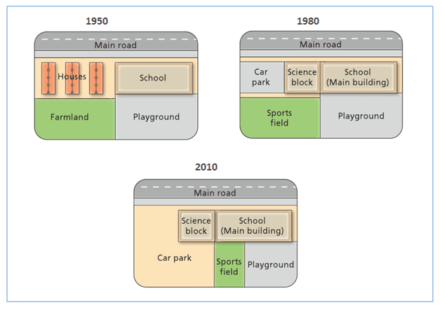
The three maps illustrate how the West
Park
Secondary Use synonyms
School
had been transformed from the beginning of the construction project in 1950 until 2010.
Use synonyms
Overall
, Linking Words
it is clear that
the Linking Words
school
had increased in size during the period given and the car Use synonyms
park
was doubled in size Use synonyms
at the end
of the construction period. Linking Words
However
, the other areas had a slight change in different years.
In 1950, the Linking Words
school
was built opposite the main road and nearby the residential Use synonyms
area
, which had the farmland located back to them. Use synonyms
Moreover
, there was a children’s play Linking Words
area
that was built behind the Use synonyms
school
. In the next 30 years, the playground remained the same but the Use synonyms
school
was expanded in a westerly direction to build a science block. Aside from the science block, there was a small car Use synonyms
park
which was built on land nearby previously occupied by houses. Use synonyms
In addition
, the farmland was demolished and changed into a sports Linking Words
field
.
In 2010, the Use synonyms
school
building remained unchanged but the car Use synonyms
park
was extended significantly more than double its original size by replacing the Use synonyms
area
of the sports Use synonyms
field
. It can be seen that the sports Use synonyms
field
was moved into the playground Use synonyms
area
, dividing the children's play Use synonyms
area
space in half to share the Use synonyms
area
with the Use synonyms
field
.Use synonyms