The two maps below show road access to a city hospital in 2007 and in 2010. Summarise the information by selecting and reporting the main features, and make comparision where relevant

The two maps below show road access to a city hospital in 2007 and in 2010. Summarise the information by selecting and reporting the main features, and make comparision where relevant
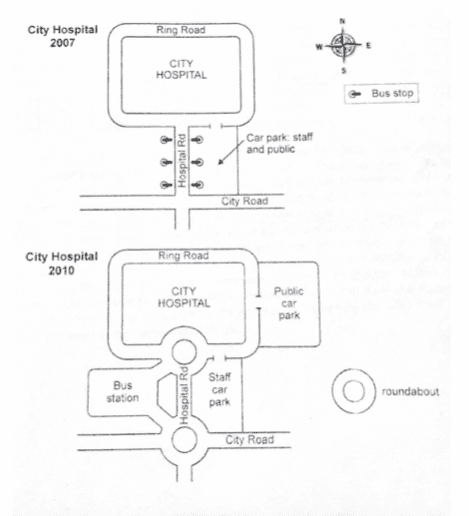
The given maps illustrate the changes and the renovations that were made on the entrance road to a
city
hospital between 2007 and 2010.
Overall
, public transportation stations and road maintenance were more moderate and accessible to both public and private vehicles near the
city
hospital in 2010 than in the previous years. Regarding the analysis in 2010, it can be seen that the bus stop was removed and replaced by the public car park on the east side of the
city
hospital .
In addition
, the roundabout was built near the parking area on the east side in 2010
also
,
while
the park in
this
position was only kept for the employees of the hospital.
Whereas
, a bus station was added on the west side of the
city
hospital which gave access to the two newest roundabouts that were installed in 2010 to extent widen the path of the
city
hospital.

Unauthorized use and/or duplication of this material without express and written permission from this site’s author and/or owner is strictly prohibited. Excerpts and links may be used, provided that full and clear credit is given to Writing9 with appropriate and specific direction to the original content.

Basic structure: Change the third paragraph.
Vocabulary: Replace the words city with synonyms.
Vocabulary: Only 5 basic words for charts were used.
Vocabulary: The word "give" was used 2 times.
Vocabulary: Use several vocabularies to present the data in the third paragraph.
Topic Vocabulary:
  • infrastructure, development, expansion, accessibility, comparative analysis, layout, direction, emergency services, facilities, pedestrian paths, urban development, strategic planning
What to do next:
Look at other essays: