
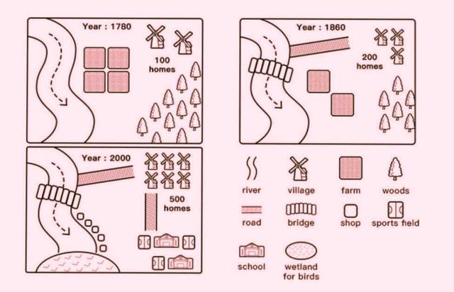
The maps illustrated how a town named Willington changed in the years 1780, 1860, and 2000. From an
overall
perspective, it is apparent that the village became more modern over the surveyed years, including a new bridge, road, villages, shops, sports fields, school, and wetland for birds. Noticeably, the Linking Words
river
remained unchanged.
In 1780, only 100 Use synonyms
homes
in Willington were situated to the northeast side Use synonyms
along with
significant woods to the south Linking Words
while
the Linking Words
center
was a place for farming purposes. The Change the spelling
centre
river
flew from the north to the south which was unaltered by 2000. By 1860, the village gradually developed by adding 100 Use synonyms
homes
more Use synonyms
while
the woods and farms were reduced much for that reason. A new bridge was constructed in order to go through the Linking Words
river
and a road led from the Use synonyms
river
to the residential area.
Regarding the remaining map in 2000, the town had considerable development by adding more than double in size of Use synonyms
homes
(500), new sports fields and schools were constructed for exercising and learning purposes in the southeast with a road connecting them and Use synonyms
homes
. On the right side of the Use synonyms
river
appeared a bunch of shops Use synonyms
while
Linking Words
at the end
of the Linking Words
river
had been placed a wetland for birds.Use synonyms