
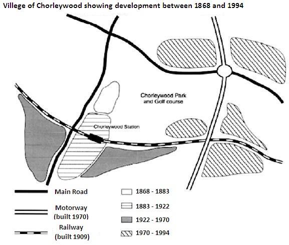
The map explains the
overall
development of Chorleywood Linking Words
village
near London over 126 years (1868 to 1994), where steady growth in people and amenities can be observed.
In an overview, transportation infrastructure seemed to be the basis of the progress of Chorleywood Use synonyms
village
.
Use synonyms
Initially
, two main roads were observed to connect the Linking Words
village
one of the roads was situated to the north and connected east-west of the Use synonyms
village
, Use synonyms
while
the other was to the west of the Linking Words
village
and ran north-south.The community was seen to be restricted to a small area to the east of the north-south main road indicating no major change between 1868 and 1883.Use synonyms
However
, after the construction of the railway in 1909 located to the south, the community first dispersed to and Linking Words
then
around the rail station over 87 years (1883-1970) suggesting steady progress.
More importantly, the establishment of the motorway in 1970 enhanced Linking Words
further
population expansion to and around the motorway over 24 years (1970-1994).The motorway was situated to the east of the Linking Words
village
running parallel to the main road of the west.Use synonyms
Besides
Linking Words
this
, Chorletywood Park and a Golf course were noticed implying complete facilities in the Linking Words
village
.Use synonyms