The map below shows the development of the village of Ryemouth between 1995 and present. Summarise the information by selecting and reporting the main features and make comparisons where relevant.

The provided maps illustrate the changes that have occurred in the village of Tynemouth from 1996 to the present.
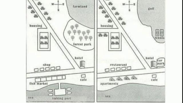
Overall
, the maps show an alteration from a mainly rural to a largely urban area.
In the initial map, a significant portion of the northeast was occupied by farmland, while
, the eastern region was encompassed by forest parks. They have been replaced by a golf pitch and tennis court at the moment. There has been a noticeable increase in residential housing in the northwest with the additional being constructed in the northern part of the village. Conversely
, The shops that once existed in the West have been replaced with restaurants.
The fishing port previously situated in the south has been completely removed from the map. Additionally
, the fish markets near the former fishing port have been substituted with apartment complexes. The hotel and the café have remained in the same location and size, however
, the car park has been introduced adjacent to the hotel.Submitted by zuleykhaaliyeva223 on
Unauthorized use and/or duplication of this material without express and written permission from this site’s author and/or owner is strictly prohibited. Excerpts and links may be used, provided that full and clear credit is given to Writing9 with appropriate and specific direction to the original content.
Vocabulary: The word "maps" was used 4 times.
▼