
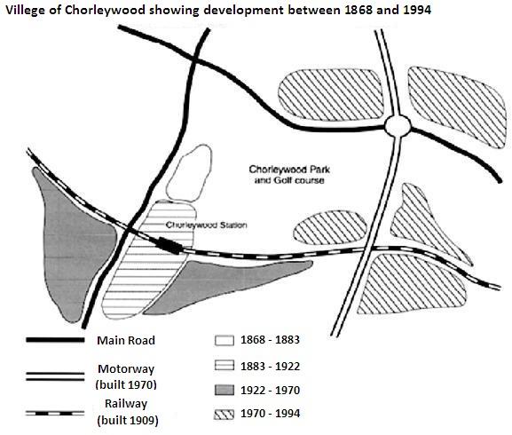
The provided map shows the location of
Chorleywood
which is one of the English villages located near London. The given map describes the changes that took place in the location in a span of approximately 100 years from 1868 to 1994. A number of modifications were implemented and they will be discussed in the lines below.
Use synonyms
Overall
, after looking at the developments and modifications, it can be plainly seen that these variations were for the well-being of the locals of that village. These constructions would accommodate the essential needs of citizens and allow them to travel easily.
Over the period , the area witnessed a dramatic change as more ways of transportation were built. First of all, concerning the first period, there were only two main roads for the locals to commute with no main roads in the Southeast regions of that village . Linking Words
Furthermore
, in the year 1970, a new motorway was constructed in the east of the area. Linking Words
Moreover
, in 1909, Linking Words
Chorleywood
went through a spectacular transformation when a railway was constructed for the first time in the south of the village. Use synonyms
Finally
, it is worth noticing that over a span of 24 years from 1970 to 1994, the Linking Words
Chorleywood
station was set up next to the Use synonyms
Chorleywood
park in the centre.Use synonyms