The map below is of the town of Canterbury. A new school (S) is planned for the area. The map shows two possible sites for the school. Summarise the information by selecting and reporting the main features, and make comparisons where relevant.

The map below is of the town of Canterbury. A new school (S) is planned for the area. The map shows two possible sites for the school.

Summarise the information by selecting and reporting the main features, and make comparisons where relevant.
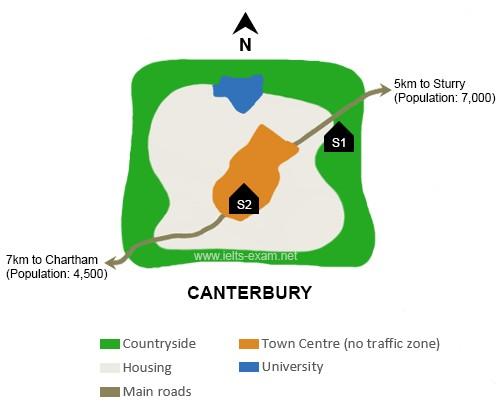
The map provides information on the proposition of two potential locations for the new school in
Canterbury
town
.
Overall
, it shows that one site is located in the countryside,
while
the other place is in the township centre. On the one hand, looking at the proposed first location for the school, one noticeable feature based on the map is that it will be built in the countryside on the west side of
Canterbury
.
This
location will be very convenient for
Canterbury
Town
and its neighbour, Sturry
Town
, which has a population of 7,000 people.
Furthermore
,
this
proposed site will
also
be adjacent to the main roads.
Therefore
, accessible to everyone.
On the other hand
, the second site will be constructed in the centre of
Canterbury
Town
, inside the township centre.
In contrast
to the other plan, there is no road adjacent to the area.
However
,
this
is accessible by the road on the west that connects
Canterbury
to Chartham
town
, which is 7 km away with a population of 4,500 people.
Submitted by meliarizkina86 on

Unauthorized use and/or duplication of this material without express and written permission from this site’s author and/or owner is strictly prohibited. Excerpts and links may be used, provided that full and clear credit is given to Writing9 with appropriate and specific direction to the original content.

Basic structure: Change the third paragraph.
Vocabulary: Rephrase your introduction. Words match: 67%.
Vocabulary: Replace the words canterbury, town with synonyms.
Vocabulary: Rephrase the word "information" in your introduction.
Vocabulary: Only 4 basic words for charts were used.
Vocabulary: The word "map" was used 2 times.
Vocabulary: Use several vocabularies to present the data in the third paragraph.
Topic Vocabulary:
  • urban planning
  • infrastructure
  • residential
  • accessibility
  • proximity
  • town centre
  • site
  • amenities
  • proposed development
  • population distribution
  • environmental impact
  • traffic congestion
  • community needs
  • educational facilities
  • public transport
  • recreational areas
What to do next:
Look at other essays: