
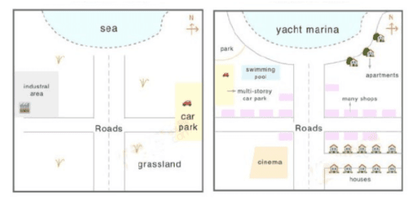
The maps illustrate how a coastal city called Petland has developed over a period of 57 years.
Overall
,what stands out from the graph is that there has been a significant development in terms of entertainment facilities and residential areas.
In the year 1950, there were two main roads which intersected each other in the centre.One of them ran from the south of the site to the north of the Linking Words
area
. To the west of it,there was an industrial Use synonyms
area
and grassland was situated in the southeast of the city.The other road led to the parking lot which was situated in the west of the town.To the top of the city,there was the large sea which occupied almost the north of the Use synonyms
area
.
In 2007,the industrial Use synonyms
area
was demolished to make way for a multi-storey car park and above it, a swimming pool was constructed Use synonyms
as well as
a park.Along each side of both roads ,a number of shops were erected and to the south of the town ,many houses were built Linking Words
as well as
a cinema.Next to the coast of the sea ,a few apartments were constructed.Linking Words